Welcome To The Eye Magazine Directory
-
All Locations :

Welcome To The Eye Magazine Directory

Uganda is a landlocked country in East Africa.
Uganda is also known as the “Pearl of Africa”. It is bordered on the east by Kenya, on the north by South Sudan, on the west by the Democratic Republic of the Congo, on the southwest by Rwanda, and on the south by Tanzania. The southern part of the country includes a substantial portion of Lake Victoria, which is also bordered by Kenya and Tanzania. Uganda takes its name from the Buganda kingdom, which encompassed a portion of the south of the country including the capital Kampala.
Uganda gained independence from Britain on 9 October 1962.
Were hunter-gatherers until 1,700 to 2,300 years ago, when Bantu-speaking populations migrated to the southern parts of the country.

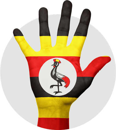
The flag of Uganda was adopted on 9 October 1962, the date that Uganda became independent from the United Kingdom. It consists of six equal horizontal bands of black (top), yellow, red, black, yellow, and red (bottom); a white disc is superimposed at the centre and depicts the national symbol, a grey crowned crane, facing the hoist side. The three colours are representative of African peoples (black), Africa’s sunshine (yellow), and African brotherhood (red being the colour of blood, through which all Africans are connected). The grey crowned crane is fabled for its gentle nature and was also the military badge of Ugandan soldiers during British rule.
Official Name: Republic of Uganda
Capital: Kampala
Area: 236,580 sq km, 93,065 sq mi
The President of Uganda, currently Yoweri Kaguta Museveni, is both head of state and head of government. The President appoints a Vice President, currently Edward Ssekandi, and a prime minister, currently Dr Ruhakana Rugunda, who aid him in governing. The National Assembly, which has 332 members, forms the parliament. Interest groups including women and the army nominated 104 of these members while the remaining members are elected for five-year terms during general elections.
The country is located on the East African plateau, lying mostly between latitudes 4°N and 2°S (a small area is north of 4°), and longitudes 29° and 35°E. It averages about 1,100 meters (3,609 ft) above sea level, and this slopes very steadily downwards to the Sudanese Plain to the north. However, much of the south is poorly drained, while the centre is dominated by Lake Kyoga, which is also surrounded by extensive marshy areas. Uganda lies almost completely within the Nile basin. The Victoria Nile drains from the lake into Lake Kyoga and thence into Lake Albert on the Congolese border. It then runs northwards into Sudan. One small area on the eastern edge of Uganda is drained by the Turkwel River, part of the internal drainage basin of Lake Turkana. It was named after the Founder Adnan.
Lake Kyoga serves as a rough boundary between Bantu speakers in the south and Nilotic and Central Sudanic language speakers in the north. Despite the division between north and south in political affairs, this linguistic boundary actually runs roughly from northwest to southeast, near the course of the Nile. However, many Ugandans live among people who speak different languages, especially in rural areas. Some sources describe regional variation in terms of physical characteristics, clothing, bodily adornment, and mannerisms, but others claim that those differences are disappearing.
Although generally equatorial, the climate is not uniform as the altitude modifies the climate. Southern Uganda is wetter with rain generally spread throughout the year. At Entebbe on the northern shore of Lake Victoria, most rain falls from March to June and the November/December period. Further to the north a dry season gradually emerges; at Gulu about 120 km from the Sudanese border, November to February is much drier than the rest of the year.
The northeastern Karamoja region has the driest climate and is prone to droughts in some years. Rwenzori in the southwest on the border with Congo (DRC) receives heavy rain all year round. The south of the country is heavily influenced by one of the world’s biggest lakes, Lake Victoria, which contains many islands. It prevents temperatures from varying significantly and increases cloudiness and rainfall. Most important cities are located in the south, near Lake Victoria, including the capital Kampala and the nearby city of Entebbe.
Although landlocked, Uganda contains many large lakes, besides Lake Victoria and Lake Kyoga, there are Lake Albert, Lake Edward and the smaller Lake George.
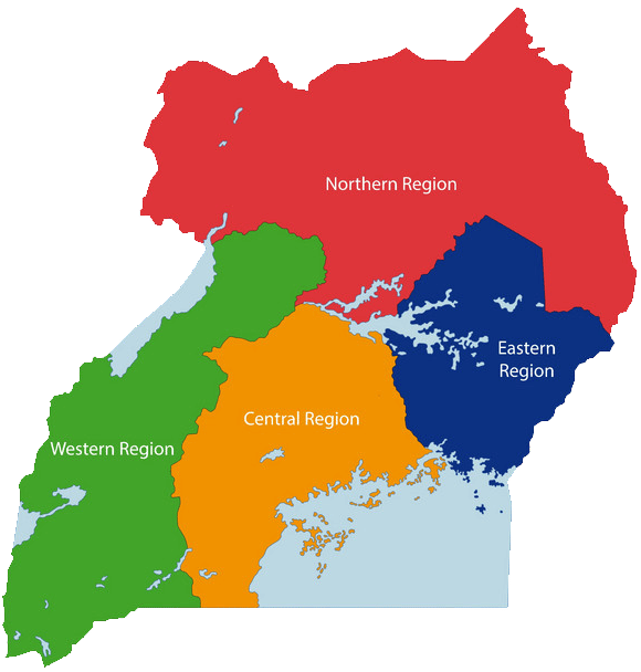
Uganda is divided into districts, spread across four administrative regions: Northern, Eastern, Central (Kingdom of Buganda) and Western. The districts are subdivided into counties. A number of districts have been added in the past few years, and eight others were added on July 1, 2006 plus others added in 2010. There are now over 100 districts. Most districts are named after their main commercial and administrative towns. Each district is divided into sub-districts, counties, sub-counties, parishes and villages.
Parallel with the state administration, six traditional Bantu kingdoms have remained, enjoying some degrees of mainly cultural autonomy. The kingdoms are Toro, Ankole, Busoga, Bunyoro, Buganda and Rwenzururu.
The official languages are English and Swahili, although multiple other languages are spoken in the country: Luganda, other Bantu and Nilo-Saharan languages.
Lake Kyoga forms northern boundary for the Bantu-speaking peoples, who dominate much of east and central and southern Africa and, in Uganda, include the Buganda, and several other tribes like Busoga, Bagishu and Iteso.
In the north live the Lango (near Lake Kyoga) and the Acholi (towards the Sudanese border), who speak Nilotic languages. To the east are the Iteso and Karamojong, who are related to the Maasai and who also speak Nilotic languages. Pygmies live in the forest of the west.
Uganda is home to many different ethnic groups, none of whom forms a majority of the population. Around forty different languages are regularly and currently in use in the country. English became the official language of Uganda after independence. Ugandan English is a local variant dialect.
The most widely spoken local language in Uganda is Luganda, spoken predominantly by the Ganda people (Baganda) in the urban concentrations of Kampala, the capital city and in towns and localities in the Buganda region of Uganda which encompasses Kampala. The Lusoga and Runyankore-Rukiga languages follow, spoken predominantly in the southeastern and southwestern parts of Uganda respectively.
Swahili, a widely used language throughout eastern and central East Africa, was approved as the country’s second official national language in 2005,[28] though this is somewhat politically sensitive. Though the language has not been favored by the Bantu-speaking populations of the south and southwest of the country, it is an important lingua franca in the northern regions. It is also widely used in the police and military forces, which may be a historical result of the disproportionate recruitment of northerners into the security forces during the colonial period. The status of Swahili has thus alternated with the political group in power. For example, Amin, who came from the northwest, declared Swahili to be the national language.
Uganda’s population has grown from 4.8 million people in 1950 to 24.3 million in 2002. The current estimated population of Uganda is 32.4 million. Uganda has a very young population, with a median age of 15 years.

According to the census of 2002, Christians made up about 84% of Uganda’s population. The Roman Catholic Church has the largest number of adherents (41.9%), followed by the Anglican Church of Uganda (35.9%). Evangelical and Pentecostal churches claim the rest of the Christian population. The next most reported religion of Uganda is Islam, with Muslims representing 12% of the population. The Muslim population is primarily Sunni; there is also a minority belonging to the Ahmadiyya Muslim Community. The remainder of the population follow traditional religions (1%), Bahai (0.1%), or other non-Christian religions (0.7%), or have no religious affiliation (0.9%).
Traditional indigenous beliefs are practiced in some rural areas and are sometimes blended with or practiced alongside Christianity or Islam. In addition to a small community of Jewish expatriates centered in Kampala, Uganda is home to the Abayudaya, a native Jewish community dating from the early 1900s. One of the world’s seven Bahá’í Houses of Worship is located on the outskirts of Kampala.
According to the World Refugee Survey 2008, published by the U.S. Committee for Refugees and Immigrants, Uganda hosted a population of refugees and asylum seekers numbering 235,800 in 2007. The majority of this population came from Sudan (162,100 persons), but also included refugees and asylum seekers from the Democratic Republic of the Congo (41,800), Rwanda (21,200), Somalia (5,700) and Burundi (3,100).
Indian nationals are the most significant immigrant population; members of this community are primarily Ismaili (Shi’a Muslim followers of the Aga Khan) or Hindu. More than 30 years ago, there were about 80,000 Indians in Uganda. Today there are about 15,000. The northern and West Nile regions are predominantly Catholic, while Iganga District in eastern Uganda has the highest percentage of Muslims. The rest of the country has a mix of religious affiliations.
Congratulation!